Free mapping tool boosts farm profits and aids future planning
28th September 2022
When fourth generation farmer Tim Hopkin was facing the loss of his family farm as it was no longer profitable, he decided to come up with a solution. The result was Land App – a free mapping platform that helps farmers plan for the future and get the revenue they deserve from their land.
As British farmers face the loss of BPS payments, soaring input costs and an array of new government schemes to get to grips with, it’s never been more important to get the most out of your land. Many are wrestling with the question of whether to continue farming, and Surrey farmer Tim faced just such a dilemma when his grandfather retired and he was advised to sell the farm.
Part of the problem was lack of data and the expense of bringing in consultants. Tim developed Land App to give farmers the tools to manage data digitally, get funding and improve profitability.
The app now has nearly 13,000 users and covers 65% of England’s farmland. Its network comprises farmers, farm advisors, land agents, estate managers, ecologists, foresters, surveyors and landscape recovery projects. The team is proud to be 100% sponsored and funded by British landowners, so everyone who has a stake in the platform is invested in the success of British farming. And, with Tim’s farming background, keeping Land App free for farmers is important.
Key aspects of the app are:
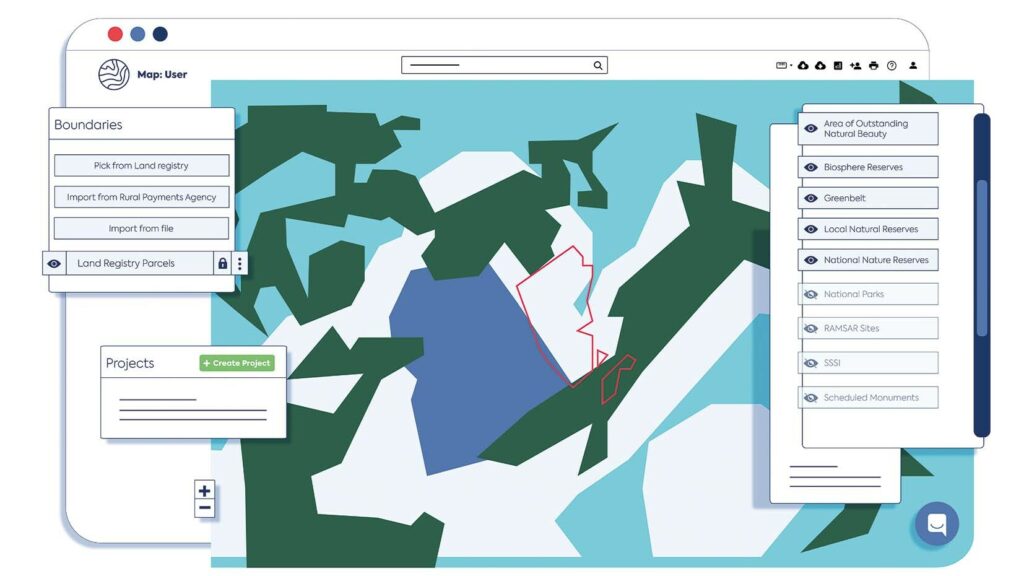
- Mapping your baseline holding and creating a ‘digital twin’ of your land
- Planning future scenarios to make an informed choice about the way forward for your business
- Collaborating with neighbours to maximise funding opportunities.
Being cloud-based means it is easy to share maps with clients, colleagues and team members. And while many traditional mapping programmes are highly technical, Land App is very intuitive – and the first of its kind when it comes to taking ownership of your land digitally, Tim adds. Plus, it’s possible to make as many maps as you like with a free account.
One user, organic farmer Martin Steer, who is also a rural consultant at Steer Ethelston Rural Limited, said: “Hardly a day passes without Land App being put to good use. Mapping forestry on Jura, CS plan designs, ‘Slow the Flow’ projects, farm water supplies, section 31 plans to local authorities and looking at the sequestration of carbon in peatlands are all simplified using the app. Within days of submitting emails with pdf of RLE1 plans and forms, we received mapping changes messages from the RPA.
“The new coordinates with What3words points have also simplified instructions to contractors.
“We’re looking forward to using the imminent mobile app in the field for hedgerow management and evidence photos for the PRA CS claims.”
How does it work?
To get started, all you need to do is set up a free account at www.thelandapp.com. Baseline maps can be viewed in satellite view or the most up-to-date Ordnance Survey view.
Users can then select from 60 data layers to find out how their land intersects with habitat, water courses, geology or B-Lines, for example – and therefore what funding they might be eligible for. The app also has a digital hook up with the Rural Payments Agency.
The app has a wide range of project templates, for example for Countryside Stewardship schemes, so users can start to mock up and design a plan. Looking ahead, Land App is also working with Sustainable Farming Incentive pilots so it will be possible to submit SFI applications through the app, as is the case with CS, saving farmers significant time.
For a Countryside Stewardship project, for example, you simply create a project on the app, enter your SBI number and create a ‘digital twin’ of your landscape. You can then instantly run a project report which will give a full breakdown of what has been mapped and the payment rate of different funding schemes. The stewardship is automatically calculated so there’s no need to get out a calculator to work out the values. The report goes straight into Excel so it can be easily submitted for application.
The benefits
Farmers continue to face an unprecedented mix of challenges, and uncertainty remains rife. “Land App is helping a lot of our customers get on top of things and understand what their value is. We can move into a new era of land management,” Tim says.
One feature of the app that has proved particularly popular is the ability to collaborate – when designing a plan users can add the email address of their ecologist or land agent, for example, click ‘add viewer’ and they will be able to view the plans.
In addition, with lots of farms and estates in the process of bringing together all the new legislation from government, funding applications and private sector funding, the app makes it easy to assess your options.
“I think what everyone’s going to be concerned with going forward – regardless of whether they are working to improve the environment or increase food production – is the balance sheet. If you have a platform to draw up future plans, and compare how much each scenario is worth, with all the options and opportunities at your disposal, you can make informed decisions.”
Tim is keen to stress that anything users create on the platform is 100% owned by the user and they have full access and control of where it’s used – Land App does not have access to the data and nor do your neighbours. It’s a totally secure process. Tim adds: “Data is not something to be scared of; it’s to be used and leveraged to people’s benefit.”
To sign up visit: https://thelandapp.com. Tutorials are also available via Land App’s YouTube page.